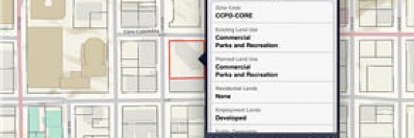
The San Diego Parcel & Property Information app presents parcel, zoning, and demographic data via an intuitive map interface.
Read More
The San Diego Parcel & Property Information app presents parcel, zoning, and demographic data via an intuitive map interface.
Read MorePhotos from the March 16th LA Spatial meetup are now online. (view album) The event was hosted by Factual at their beautiful corporate headquarters in Century City.

We had a great group of about twenty geo nerds there to hear a presentation by Tyler Bell, the Director of Product at Factual. Tyler talked about the evolution of the geo sector and examined how POI provide a more useful geographic context to end users than longitude and latitude.

Visit the LA Spatial meetup page to learn more. If you'd like to come to future events, then join our group!
Read MoreThese maps the show the severity and frequency of seismic activity affecting the people of Japan during this past week. The Huffington post has compiled a list of Japan Earthquake Relief Options. Please help if you can.

Just three short weeks ago, James and I were part of the team that won Startup Weekend Los Angeles.

The Zaarly team at LA Startup Weekend
Zaarly generated a lot of buzz that hasn't let up since. It's currently being released as a private beta at SXSW. Watch the following TechCrunch interview with Bo Fishback to learn more.
In three weeks, Bo Fishback, Eric Koester, and Ian Hunter have taken this from concept to launch. That's mind bottling.
Read MoreWith great concern, we have been following the reports of powerful earthquakes and tsunamis in Japan, including the 8.9 quake earlier today off the coast of Honshu. Our thoughts and prayers are with those affected, as well as the people of Christchurch, New Zealand and Haiti.
There are many organizations working to provide earthquake relief in these countries. If you would like to donate, here are a few that you may consider.
Global Giving – Japan Earthquake and Tsunami Relief Fund
http://www.globalgiving.org/projects/japan-earthquake-tsunami-relief/
New Zealand Red Cross 2011 Earthquake Appeal
http://www.redcross.org.nz/donate
Partners in Health – Stand with Haiti
http://www.standwithhaiti.org/haiti
For those who have loved ones in Japan, Google has created Person Finder to help friends and family stay connected.
Read MoreLinda Richards, the CEO of Artisan Global, was recently selected for the 10,000 Small Businesses program, created by Goldman Sachs.
This $500 million initiative will unlock the growth and job-creation potential of 10,000 small businesses across the United States through greater access to business education, mentors, networks, and financial capital.
The program includes:
The selection process was very competitive and the skills that Linda is learning are key to helping us grow Artisan Global. We're excited about the years ahead and the opportunity to create more jobs here in Southern California.
Read More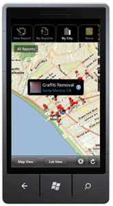
The CitySourced WP7 app is now available in the Windows Phone Marketplace and was recently featured on the MSDN blog.
CitySourced is a real time mobile civic engagement tool that empowers citizens to identify civic issues (potholes, graffiti, trash, snow removal, etc.) and report them to city hall for quick resolution.
Artisan Global LLC integrated the ESRI ArcGIS API for Windows Phone into the application. We also implemented WP7 tombstoning and client side image processing.
Read MoreWe've scheduled the next meetup for the Los Angeles Spatial / Location Developers group.
DATE: Thursday, Feb 3rd at 7:00 pm
LOCATION: CoLoft, 920 Santa Monica Blvd, Santa Monica, CA 90401 (map)
TOPIC: Building Map Applications with ArcGIS for Windows Phone.
Microsoft is co-sponsoring this event and we're honored to have Rex Hansen, Product Lead/Architect from Esri, as our presenter.
Rex will show you how the ArcGIS API for Windows Phone enables you to build and deliver rich, interactive mapping applications for the Windows Phone 7 platform. He will provide an introduction to the API, discuss topics on how to get started, and discuss development patterns and practices. Rex will also present and review the ArcGIS application available in the Windows Phone Marketplace.
For more information, visit the Meetup event page. We hope to see you there!
Read More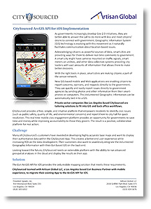
For those of you who missed the ArcGIS for the iPhone and iPad webinar hosted by Esri and Directions Media, the recording of this event is now available.
View now: ArcGIS for the iPhone and iPad (registration required)
James Richards, President of Artisan Global LLC, presented along with David Cardella, Esri’s ArcGIS Product Manager for iOS, and Kurt Daradics, the Business Development Director for CitySourced.
Kurt discussed how the CitySourced app increases ROI for their clients. (Begins at 15:30) James presented best practices for working with ArcGIS for iOS. (Begins at 22:45)
For this event, Artisan Global and CitySourced also collaborated on a technical white paper.
The paper begins with an overview of the CitySourced app and the reasons why they migrated to the ArcGIS API for iOS.
A technical discussion follows, with code samples that show:
Dowload now: CitySourced ArcGIS API for iOS Implementation
James Richards will be expanding on these topics and more in the coming weeks on his blog Programming and the GeoWeb.
Read MoreQuakeFeed is now available in the App Store! Download Now
Created with ArcGIS for iOS, QuakeFeed has the most features of any free earthquake app. Six beautiful base maps are provided by Esri, the world leader in GIS.
The app displays all earthquakes from the past 7 days with a magnitude > 2.5 on a map or in list. A variety of filter and sort options are provided. The app is location aware so you can find quakes that are closest to you. It has a intuitive user interface and features Twitter, Facebook, and email integration.

For more information, visit the QuakeFeed site: http://quakefeed.net
Feedback and ideas can be reported on Get Satisfaction: http://getsatisfaction.com/artisanglobal
Read More