Archives for

QuakeFeed… a not-so-humble brag!

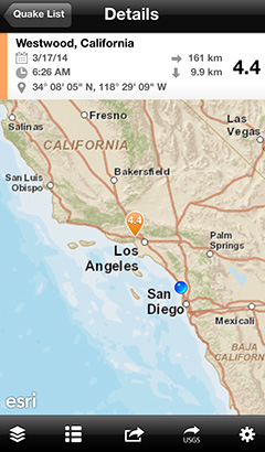
Yesterday there was an M4.4 earthquake in Los Angeles. Although Californians are no strangers to quakes of this magnitude, it was the largest one to strike the city in years. It also served as a reminder of the importance of earthquake preparedness, coming on the heels of the 20th anniversary of the devastating 1994 Northridge Earthquake.

In addition to this earthquake, there has been much seismic activity recently around the globe. Northern California, Chile, Peru, Japan, Nicaragua, and Barbados have all seen quakes over magnitude 6.0 during the past 30-days.

M6.7 earthquake and aftershocks off the coast of Chile

The midwest also continues to experience many earthquakes. There has been a significant increase in seismic activity in states such as Oklahoma and the people who live there are very concerned. Further research is needed to determine whether these earthquakes are man-made, caused by the injection of wastewater in deep disposal wells.

44 earthquakes in Oklahoma and Kansas during the past 7 days

We have a high level of engagement with the community of QuakeFeed users. Every day, we receive dozens of emails from people all around the world. Many live in earthquake zones or else have family and friends who do. Some are teachers or emergency management professionals. They express their thanks and offer valuable suggestions on how to make the app even better. And they remind us how fortunate we are to provide a valuable service to people, doing something we love.

Download QuakeFeed for free, see why we’ve earned 5-stars and rave reviews!

Read More

Using iBeacons with the ArcGIS Runtime SDK for iOS

We’re excited to be working with Stadium Apps to develop their Venyoo app using the ArcGIS Runtime SDK for iOS.

The ArcGIS Runtime SDK for iOS is Esri‘s native Objective-C API for deploying maps, geocoding, routing, and spatial analysis capabilities to iPad, iPhone, and iPod touch devices.

Venyoo has beautiful maps, created in ArcGIS for Desktop and rendered as tile packages that can be included in the app download. In other words, the maps work offline while the user is inside the venue without GPS availability.

Venyoo brings together the robust offline mapping capabilities offered by the ArcGIS platform with iBeacon technology to provide the user with contextual information as they move about the venue.

Beacons are a low-cost piece of hardware, small enough to attach to a wall or countertop, that use Bluetooth Low Energy technology to transmit a signal similar to WiFi.

Each beacon broadcasts a unique signal that can deliver personalized, micro-location based notifications and actions to any smart device within its range.

Venyoo uses beacons to solve the indoor routing challenge. By placing beacons strategically around the venue (in each seating section, at concessions, rest rooms, stairways, exits, etc.) a sensor network is created. Venyoo can recognize which beacon is closest and provide accurate navigation instructions.

Less time trying to find your seat or where to buy fries means more time enjoying the game.

When an event goer walks into a merchandise establishment, Venyoo will notify them of specials or coupons. While standing in line at a concession, Venyoo can crowd source the line size and display this information on the map.

While exiting the stadium after the game, Venyoo can deliver a thank you message along with a schedule of upcoming events.

The more we work with the iBeacon technology, the more use cases and opportunities we identify. So far, we’ve integrated the beacons from Estimote, which are quite attractive looking and a breeze to work with. Next we will integrate the Gimbal beacons by Qualcomm.

We’re also exploring ways to take advantage of the Esri’s ArcGIS Geotrigger Service to enhance the Venyoo experience. For example, geotriggers could be used to save battery life by turning the iBeacon ranging on/off when entering/exiting the venue.

But beacons may already have a rival in the  Smart LED Lighting systems from Philips and ByteLight. It will be interesting to see how this fast moving area of technology plays out.

Read More

Stadium Apps Demo from Startup Weekend

It’s been four weeks since our smashing debut at the Entertainment and Media Startup Weekend so it’s about time that we give you a peek at what we’re creating!

Here is a short video of the prototype that we built using the Esri Runtime SDK for iOS. Some of the features shown include:

  • Search for specific concessions
  • Search results include: vendor name, crowd-sourced rating, stadium level, relative price index, current line size, walk time
  • Location of concession on map with shortest walking route
  • Swipe to scroll through search results and update map
  • View menu details for a specific concession
  • View seating charts by level

Scott Larson really nailed his presentation on the final night of Startup Weekend and James finished the demo right at the bell, to thunderous applause. They re-envisioned Stadium Apps as a standalone consumer app called Venyoo.

We generated a lot of buzz coming out of Startup Weekend! Since then, Scott been on a whirlwind tour of meetings with potential customers, partners, and investors. He seems to be gaining more traction with the white label approach, but has not ruled out creating a consumer facing app.

Meanwhile, James is incorporating iBeacon functionality into the prototype and will soon explore Esri’s Geotrigger SDK, scheduled for release next month.

Read More

Stadium Apps Goes to Startup Weekend

As luck would have it, the first ever Entertainment and Media Startup Weekend is happening this weekend in Los Angeles. It’s a perfect opportunity to build momentum for Stadium Apps, so of course we’re jumping right in!

Startup Weekend is a fast-paced, 54-hour event where budding entrepreneurs, designers, coders, etc form teams to jump start a business idea, build as much of it as they can over the course of the weekend, then give a 5-minute presentation at the end. A panel of local entrepreneurial leaders offer feedback and winners are chosen in various categories.

It’s competitive – make no mistake about that – but the atmosphere is fun, friendly, and very supportive.

James and I were on a winning Startup Weekend team back in 2011. If there is one thing I learned that weekend, it’s that there is absolutely no substitute for passion. Our team leader, Bo Fishback, swept everyone up into his wake of enthusiasm. He had the kind of fire that burned obstacles right out of the way and it stunned me how much the team accomplished.

So we’re coming into this with tall ambitions about what we will create and have ready for the final presentation. It’s even more exciting that this event is focused on  developing new and fresh ideas centered around the viewing and creation of entertainment and media.

“Do you have an idea of how to deliver our sports, music, news, movies, TV, and gaming in a more meaningful and engaging way? Or maybe these industries could benefit from today’s technology?”

Why yes – we do… and they can!

If you’re planning to be there this weekend, please stop by and say hello to our team.

Read More

Getting Started with Stadium Apps

When we start working with a new customer, the first thing we often do is a small prototype project that is very limited in scope, time and budget. It’s a low risk way to prove the concept, the technology, and our expertise. Once we get this initial project successfully under our belts, the road ahead becomes more clear.

The project we’re doing for Scott Larson from Stadium Apps is just that. We’re prototyping one specific use case – the ability to search nearby concessions and merchandise while you are at the stadium. It will serve two primary purposes:

  • Get some of the technology pieces in place (Esri, Micello, etc)
  • Have something awesome to show during presentations

Based on our conversations with Scott (and after doing some competitive research), James and I created paper sketches for the needed screens. We’re incorporating some of the best UI design practices used by popular mapping apps while taking advantage of the rich cartography capabilities that are unique to the Esri platform.

Read More

Field Inspection App

Artisan Global developed a field inspection iPad app for a utility services company using Esri’s ArcGIS Runtime SDK for iOS.

Read More

Introducing… Scott Larson of Stadium Apps

In my last post, I mentioned how fired up Scott Larson is about Stadium Apps. I thought it would be nice for you to meet him yourself and hear his perspective on things as this story unfolds. With that in mind, he has offered to write a few guest blog posts that we can share with you here.

Building an app is so much more than writing code. I think most would agree that the technology is really just the tip of the iceberg. This first post from Scott gives you just a peek into how much hustle and passion he’s putting into bringing his vision to life.

Building a start-up is hard work, not doubt about it.  First of all, there is the chicken or egg problem (more to come on that topic later).  But needless to say, I’ve been taking all kinds of meetings in the attempt to get feedback on what we are building as a prototype, with help from Linda and James.

I spent last weekend in Silicon Valley, the heart and soul of not only tech but the start-up community in general.

Read More

Play ball!!

Most of the work we do is performed under non-disclosure agreements that prevent us from talking about it. But right now we’re just starting a new project with a customer who would LOVE for us to talk. So over the coming weeks, we’re going to tell the whole story from start to finish.

This project came to us via our good friends at team A design. We collaborated with team A on a flight tracking iPad app a little while back. Recently, they introduced us to Scott Larson from Stadium Apps as the go-to people for iOS apps with robust mapping capabilities.

I must confess – I’m a fair-weather sports fan at best. But during our initial talks with Scott, he was so fired up and passionate about Stadium Apps that I found myself suddenly wanting to take my son to a Padres game. His enthusiasm was quite contagious.

Read More

QuakeFeed is the top iPad earthquake app

With over 230K active users and a 5-star rating, QuakeFeed is the top ranked earthquake app that runs on both the iPad and iPhone.

Version 2.3 was released in late 2012, with the following new features and enhancements:

  • Push notifications: free for all quakes M6.0 and above; custom notifications by magnitude / location available with In-App Purchase
  • More USGS Data Feeds: 1-day, 7-day, or 30-day with M1.0+ or M2.5+
  • Curated earthquake news and announcements
  • Plate lines
  • GPS button
  • Optional map marker styles
  • Plus a variety of UI improvements

Version 3.0 will be available soon, featuring full iOS 7 capability.

QuakeFeed iPad App v2.3

Read More

Lake Forest Mobile Maps

Artisan Global designed and developed a series of web and mobile maps for the City of Lake Forest using HTML5 and the Esri Javascript API.

Read More