Archives for

ArcGIS for iOS Webinar Happening Today

Over 1,100 people have registered for today's ArcGIS for the iPhone and iPad webinar hosted by Directions Media.

James Richards, President of Artisan Global LLC, will present along with David Cardella, Esri's ArcGIS Product Manager for iOS, and Kurt Daradics, the Business Development Director for our client CitySourced.

James and Kurt will talk about how smartphone apps promote real-time field collaboration and information sharing. James will also present a few best practices for working with ArcGIS for iOS.

This free webinar event will begin at 2:00 PM EST / 11:00 AM PST. To register, visit https://www2.gotomeeting.com/register/882551307.

A recording of the event will also be available for download, in case you're not able to attend.

Read More
Property ID iPhone App Available Now

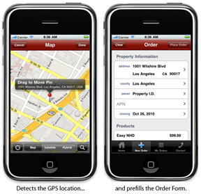
The Property I.D. iPhone app is available now in the App Store!

This free app allows real estate agents to order natural hazard disclosure reports based on their current GPS location. The property address can also be searched on a map or pulled from the iPhone contacts. Users can view and track the status of their orders and forward PDFs of the reports to their clients via email.

James Richards from Artisan Global LLC designed and developed the iPhone app, along with the backend ArcGIS Server spatial analysis engine that generates the reports.

To see this app in action, visit: http://www.youtube.com/propertyid

Read More

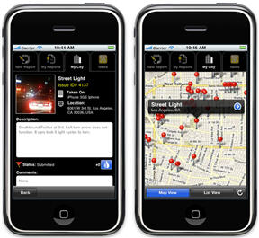
CitySourced App with Esri Maps

The new version of the CitySourced app that uses the ArcGIS for iOS API is available now in the App Store. James Richards of Artisan Global LLC performed the ArcGIS for iOS integration into the iPhone version of the app and is currently performing the Windows Phone 7 integration.

CitySourced is a real time mobile civic engagement tool that empowers citizens to identify civic issues (potholes, graffiti, trash, snow removal, etc.) and report them to city hall for quick resolution. This free mobile app was featured during the Plenary Session of the ESRI 2010 UC and also at TechCrunch50.

James Richards and Kurt Daradics, the Business Development Director for CitySourced, will demo the app and share best practices at the ArcGIS for the iPhone and iPad webinar hosted by Directions Media on Tuesday, November 16 at 2:00 PM EST.

For more information or to register for this free webinar event, visit https://www2.gotomeeting.com/register/882551307.

Read More

James Richards to Present at 2010 DevGeo Silicon Valley

James Richards, President of Artisan Global LLC, will be the Guest Speaker at DevGeo Silicon Valley.

James will talk about how to create engaging mapping experiences for mobile users and how to get started writing iPhone apps with the ArcGIS API for iOS.

The event also features a panel discussion and breakout sessions for all of the ESRI client APIs: JavaScript, Flex, Silverlight / Windows Phone, and iOS.

This free event will be held in Santa Clara, CA on Thursday, November 04, 2010 from 12:30–6:30 pm.

For more information or to register, visit http://esri.com/devgeo. Space is limited, register early!

Read More

Next LA Spatial Meetup on October 12th

The next meetup for the Los Angeles Spatial / Location Developers group will be Tuesday, October 12th at 7:00 pm.

Brian Goldin, co-founder of Voyager GIS, will give a presentation on using web style search for locating geospatial data. James Richards will present an introduction to geocoding and demonstrate how to integrate geocoding services into your apps.

The meetup will be held at the offices of NorthSouth GIS, located at 312 E First Street, Suite 300 in downtown Los Angeles.

For more information, visit the LA Spatial October 12th meetup page.

All are welcome, from seasoned GIS professionals to those new to geospatial technology. We hope to see you there!

Read More

Artisan Global will Integrate ArcGIS API for iOS into CitySourced

CitySourced has asked Artisan Global LLC to integrate the ESRI ArcGIS API for iOS into the iPhone version of their application.

The CitySourced app is a real time mobile civic engagement tool that empowers citizens to identify civic issues (potholes, graffiti, trash, snow removal, etc.) and report them to city hall for quick resolution.

CitySourced was featured during the Plenary Session of the ESRI 2010 UC and also at TechCrunch50.

Read More

Los Angeles Spatial / Location Developers Meetup

James and I have organized a new meetup group called Los Angeles Spatial / Location Developers. This meetup is for software developers working with any spatial or location enabled platforms. All levels of developers are welcome, from seasoned GIS professionals to those new to geospatial or mobile location development.

Our first meetup will be at the CoLoft in Santa Monica on Tuesday, July 27th at 7:00 pm. James will give a presentation on Getting Started with the ESRI ArcGIS API for iOS. This API enables you to build iPhone apps that utilize mapping, geocoding, geoprocessing, and other capabilities provided by ArcGIS Server.

For more information, visit the LA Spatial meetup page.

If you're in the Los Angeles area, we hope to see you there!

Read More

LA Citywide GIS Contract – Fully Executed

We just received the fully executed Citywide Geographic Information Systems contract from the City of Los Angeles.

This contract places Artisan Global on a list of approved vendors to provide "as needed" GIS application development services for all departments of the City of Los Angeles.

This was a very competitve RFP and only a short list of vendors were selected. We're proud that our hard work has paid off and we're looking forward to new project opportunities with the City.

Read More

ESRI ArcGIS iPhone API – Class Breaks Renderer Sample

James has written a new article on Programming and the GeoWeb that demonstrates the use of a Class Breaks Renderer in the ESRI ArcGIS iPhone API. The code sample queries an ArcGIS Server Map Service for cities in California and renders them as graphics based on the population.

The source code is provided for download.

Full article: ESRI ArcGIS iPhone API – Class Breaks Renderer Sample

Read More

ESRI ArcGIS iPhone API – Integration with Core Location

James has written a new article on Programming and the GeoWeb that discusses how to use Apple's Core Location framework with ESRI's ArcGIS iPhone API.

In the article, James extends the example from his previous post to demonstrate how to get the current location and zoom to it while showing a custom graphic on the map.

The source code is provided for download.

Full article: ESRI ArcGIS iPhone API – Integration with Core Location

Read More